The assignment of creating a geolocation-based lesson culminated in a rubric for the purposeful inclusion of instructional technology when teaching in an inclusive classroom.

Geolocation Lesson
A Geolocation lesson I would propose is teaching longitude and latitude to 4th-5th graders in either social studies or science. I would start with the trade book The Librarian who Measured the Earth (Lansky, 1994). And continue as a read-aloud, Around the World in a Hundred Years (Fritz, 1998). By considering the real and manmade lines on the Earth the ideas of seasons and longitude and latitude can be introduced. I would follow it up with the video, Eratosthenes: Measurement of the Earth’s Circumference (2015) within the learning management system to connect the manmade lines to the real world.
Integration opportunities: mathematics, social studies, science, writing, reading
Handheld Technology for the Teams
After longitude and latitude are part of the classroom vocabulary it is time to experience how longitude and latitude work on a micro-level with a geocache scavenger hunt around the exterior of the school. The students will be put into teams of 3-4 students and given Garmin eTrex 10 Worldwide Handheld GPS Navigator borrowed from the 6-12 science department. Adults will be invited into the school for this special adventure. One adult to a small group and adults posted around the school grounds as special docents to guide, update, adjust the travel of the small groups of students and adults. Robinson and Hardcastle (2016) found that time was the single largest reported barrier to enjoying geocaching, so the teacher can create time in the school day for this
Inclusive Supports
Adults will be provided a video to learn how to use the device and meet with one student member of the group, the technology expert, in advance of the adventure. The device is intuitive enough for students to operate with the adult and experts’ help. Additionally, the device is small enough for all to take a turn handling and reading. Additionally, adults will be asked to read the blog post Geocaching 101: Latitude and Longitude (Writer, 2021) in order to help students make connections to prior knowledge when on the adventure.
The teacher will purposefully create groups that could include any exceptional students, which include roles: a technology expert, a mapmaker/reader, a mathematician. Other possible roles to include more students per group could be the recorder and the presenter. The adult chosen to accompany each group should be intentionally selected for any member exceptionalities, possibly a paraprofessional of special education teacher to assure any accommodations. Ideally, the supportive adult works with exceptional students and the group to model independent learning skills and strategies (Stanford, et al., 2010).
The initial geocache includes pencil topper erasers for students. The students will be prepared for the size of their “treasure” and asked to bring something of equal size to leave for the next adventurers. The container will be a plastic box 6 by 8 by 12 inches and contain a small handheld notebook with an attached pencil for all students to earn credit for completion of the adventure and the treasures themselves.
When students return to the classroom after all the successful adventures the teacher will regroup by role. In these new groups, students will prepare for presenting within their group and then to an audience (parents, teachers, upcoming students) later in the week. At this time any exceptional students may be pulled into a smaller grouping to prepare for presenting as needed.
Differentiation for Instructional Technology Rubric
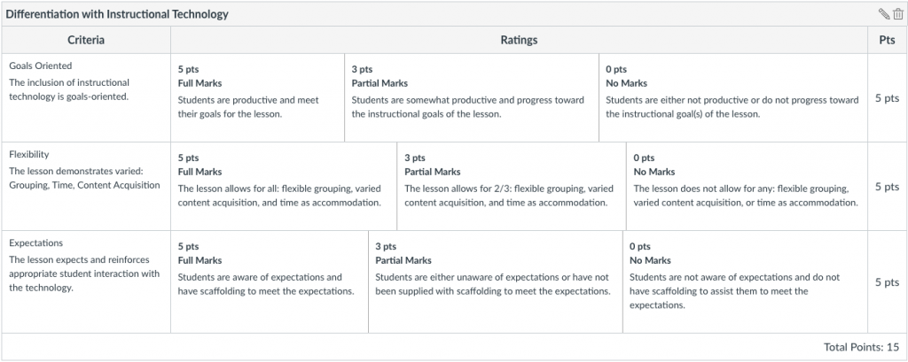
An appropriate rubric to evaluate this lesson and any lesson with the inclusion of instructional technology with an inclusive classroom is given in Figure 1. The criteria I examined were if the inclusion of the technology was goals-oriented for the students if the way students interacted with the technology was flexible, and if clear expectations were both present and supported at the needed level for each student. My lesson plan meets all these criteria.
Figure 1
Differentiation with Instructional Technology Rubric

References
Eratosthenes: measurement of the Earth’s circumference. YouTube. (2015, May 6). https://youtu.be/RzntWFHSzDQ.
Fritz, J. (1998). Around the world in a hundred years. Putnam Publishing Group.
Lansky, K. (1994). The librarian who measured the earth. Little, Brown and Company.
Robinson, S. & Hardcastle, S. (2016). Exploring the attitudes towards and experiences of geocaching amongst families in the community, International Journal of Environmental Health Research 2(26). 187-197
Stanford, P., Crowe, M.W., Flice, H. (2010). Differentiating with Technology. Teaching Exceptional Children Plus, 6(4) Article 2. http://escholarship.bc.edu/education/tecplus/vol6/iss4/art2.
Writer, G. (2021, January 12). Geocaching 101: Latitude and Longitude. Official Blog. https://www.geocaching.com/blog/2021/01/geocaching-101-latitude-and-longitude/.


1 Pingback