
I love science and educational technology. So, for one of our “staycation” stops this Spring Break was the local Scale Model of the Solar System. And because we had an extra visitor in grandma this trip I didn’t set up the timeliner app for my 7 year old. But don’t worry, I came up with a way to use all those pictures I snapped along the way.
My 1st grader still has to add his research – because every 7 year old does research on Spring Break, right? However, check out the rough draft of our Scale Model Solar System Walk in Gainesville, Georgia.
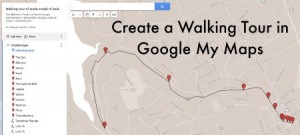
I really should have had him use the app as we travelled. But as you understand I could not just let it go. Here I was with all these images, looking to set the order of the planets in his young mind and I just had to do something. So I decided to see what Google Maps had to offer. I learned about (1) My Maps from some very nice YouTubes (thank you @kriker) and RockBlog. So I (2) posted my images to Flickr – you need them publically available. And then I (3) placed my pins on the My Map, which saves to your GoogleDrive. Finally (4) adding the image URL ending in “.jpeg” with the selected size the same for each pin on my map. I (5) connected my pins to show the walking route. And when I showed my son this morning he was actually interested in (6) going back in and adding some research for each stop on the path.
You can check out the walking tour’s home page. It was a worthwhile “Staycation” stop yesterday!

Leave a Reply